On Armistice Day, 11 November 1931, Lee Drive, the first road constructed in the Fredericksburg and Spotsylvania County Battle Fields Memorial Park, officially opened. A crowd of 3,500 led by Federal, State, and local dignitaries and citizens of Fredericksburg and Spotsylvania County gathered on Lee’s Hill for the occasion. Most had walked the 1 ½ miles up Lafayette Boulevard from the city courthouse to the ceremony site.

The Fredericksburg and Spotsylvania National Military Park (FSNMP), as it is now known, was a long time in coming. The first preserved Civil War battlefields; Chickamauga and Chattanooga, were established in 1890. This was followed five years later by Antietam, Shiloh, Gettysburg, and Vicksburg. The War Department oversaw all these parks, reflecting the desire to use the battlefields for military study and Army training grounds, as well as memorials.
In 1924, Congress established a commission to inspect the battlefields around Fredericksburg and report on the feasibility of marking and preserving them. The commission was made up of a Union veteran, a Confederate veteran, and a commissioned officer of the Corps of Engineers. The Report on the Inspection of Battlefields in and around Fredericksburg and Spotsylvania Court House, Virginia, submitted on 1 December 1925, provided the outline of which locations should be included. These were noted on an index map sheet using a “Combined Plan—Antietam System.” Unlike the five earlier military parks, which acquired large tracts of land, this approach limited land acquisition to the breastworks, earthworks, gun emplacements, walls or other defensive shelters used by the armies, and highways to be constructed and authorized to be called a national military park.
On 14 February 1927, Congress established a national military park, at and near Fredericksburg, Virginia, to mark and preserve historical points connected with the battles of Fredericksburg, Spotsylvania Court House, Wilderness, and Chancellorsville, including Salem Church, Virginia. In Fredericksburg, this included the Sunken Road and the Stonewall below Marye’s Heights.
The commission recommended building a road along the Confederate positions between Lee’s Hill and Hamilton’s Crossing. The ‘military road’ from the Civil War era had long since disappeared. This necessitated constructing a road in the battlefield because no public roads provided sufficient visitor access to important areas.
Author Joan Zenzen noted “that road building and land acquisition went together, with road construction enabled in part by a specific appropriation, a pre-New Deal unemployment relief effort.”

Lee Drive snaked next to the narrow line of Confederate trenches from Lee Hill on Richmond Road (Business Route 1), across Lansdowne Valley Road to Hamilton’s Crossing at Mine Run. Park staff cleared the underbrush along the trench line, making the trenches clearly visible along, what the local newspaper described as, “a beautiful drive”. The signs along Lee Drive were limited to specific battle actions. On Prospect Hill, Lee Drive was routed adjacent to the artillery positions to allow the visiting public to easily view them as they motored along the road. At the extreme southern end of the hill, this necessitated excavating a portion of the hill to allow the road to conveniently join the existing road to Hamilton’s Crossing.
The park was officially dedicated on 19 October 1928 by President Calvin Coolidge.
In 1933, Administrative functions of Fredericksburg and Spotsylvania County Battle Fields Memorial Park transferred to Department of the Interior and today, the National Park Service (NPS).

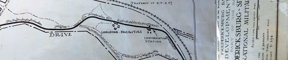
By the early 1940’s, the Park Service laid out potential improvements to enhance the visitor experience. These included hiking and horse trails, picnic areas and an information station on the top of Prospect Hill. World War II prevented any of this development. After the war, plans changed.

For the remainder of this blog, I will focus on the Prospect Hill portion of Lee Drive as it is today.

This 1942/44 US Geologic Survey (USGS) map of our study area shows the limit of development at that time. The proponents of the “Combined Plan—Antietam System” felt that the rural nature of the region would remain undisturbed into the foreseeable future”. This, in my view, was a shortsighted idea. It may have been good for the nation’s financial pocketbook, but it robbed the cultural side of our society.

As a visitor ascends Prospect Hill at its northern end, the hill or ridge appears to gently rise along the length of Lee Drive. Preserved infantry entrenchments and gun emplacements are located to the left of the road.

Lee Drive, seen from the southern end of Prospect Hill shows NPS ‘Stop 6’ on the left. There is parking for six cars or pickup trucks and two buses. The gun emplacements are found on the right side. You can see a 12-pound Howitzer in the distance. The red/orange cones are from my previous work (click here and here) when I figured out the placement of limbers and caissons associated with each gun.

This composite photograph shows NPS ‘Stop 6’ as you approach it from the north. In the distance you can make out a wooden fence, which prevents automobiles going further. This fence was installed in early 1990’s to cut off what amounted to a commuter shortcut through the park. This additional volume of traffic was endangering park visitors.

This photo looks east across the road excavation which happened when the road was built in 1927-31. At the time of the civil war, this did not exist. Rather the hill was complete. The cones in the foreground show where the back of a caisson would have stood. Those seen on the far side of the road cut marks where the rear of a limber would have stood. The rear of the caisson was approximately 144 feet, (44 meters) from it’s gun, while the limber was 76 feet (23 meters) from its gun.
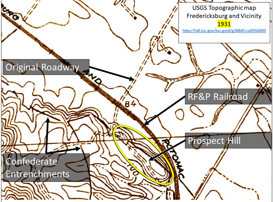
This is a small section of a 1931 USGS topographic map which indicated the location of infantry entrenchments and gun emplacements. The military road, constructed by the Confederates before the battle, was temporary in nature and disappeared for the most part by the time of the survey for this map. However, it does show a road system used by the landowner for farming in the flats to the east of the railroad, and logging to the west or left of the railroad. This road connects with Hamilton’s Crossing. When the War Department constructed Lee Drive, the portion of this existing roadway was obliterated.
My next blog (Part 2) I will take a deeper look at the road found on this map and how it was possibly connected to the confederate artillery emplacements.
Sources:
Books and Manuscripts:
Happel, Ralph. A History of The Fredericksburg and Spotsylvania Battlefield Memorial National Military Park. Fredericksburg, VA, 1955. Pp 35, 28, 45, 48-50, 54.
Zenzen, Joan. At the Crossroads of Preservation and Development: A History of Fredericksburg and Spotsylvania National Military Park. FSNMP, 2011. Pp 36, 41, 44.
Report on the Inspection of Battle Fields in and around Fredericksburg and Spotsylvania Court House, Virginia, 1 December 1925. FSNMP collection.
On-line:
Armistice Day-Veterans Day. Armistice Day – Wikipedia
Chickamauga and Chattanooga National Military Park establishment.
Antietam, Shiloh, Gettysburg, and Vicksburg Military Park establishment.
Our First National Military Park | American Battlefield Trust (battlefields.org)
10 Facts: The Birth of National Battlefield Parks | American Battlefield Trust (battlefields.org)
Legislative Histories:
Foundation Document, Fredericksburg and Spotsylvania National Military Park, Virginia (November 2015)
Newspapers:
“Park Road Opening Witnessed by Many”, Free Lance-Star, November 12, 1931.
Maps:
Fredericksburg Battlefield Development Plan, FSNPS, Drawing No. NMP-FS 2154, 194(2?).
USGS 1:31680-scale Quadrangle for Guinea, VA 1942 – ScienceBase-Catalog
USGS 1:31680-SCALE QUADRANGLE FOR FREDERICKSBURG, VA 1944 (historicaerials.com)
FRSP Map 1. Maps – Fredericksburg & Spotsylvania National Military Park (U.S. National Park Service) (nps.gov) Topographic map of Fredericksburg and vicinity, VA, showing battlefields. Topographic map of Fredericksburg and vicinity, Virginia, showing battlefields | Library of Congress (loc.gov)

You must be logged in to post a comment.