
Major General (MG) Ambrose E. Burnside’s assault against Marye’s Heights was a disaster. Today that assault is the stuff of legend and myth. Failure has many stepchildren; the Battle of Fredericksburg is no exception. Today, I explore the impact that fences contributed to the outcome of the battle.
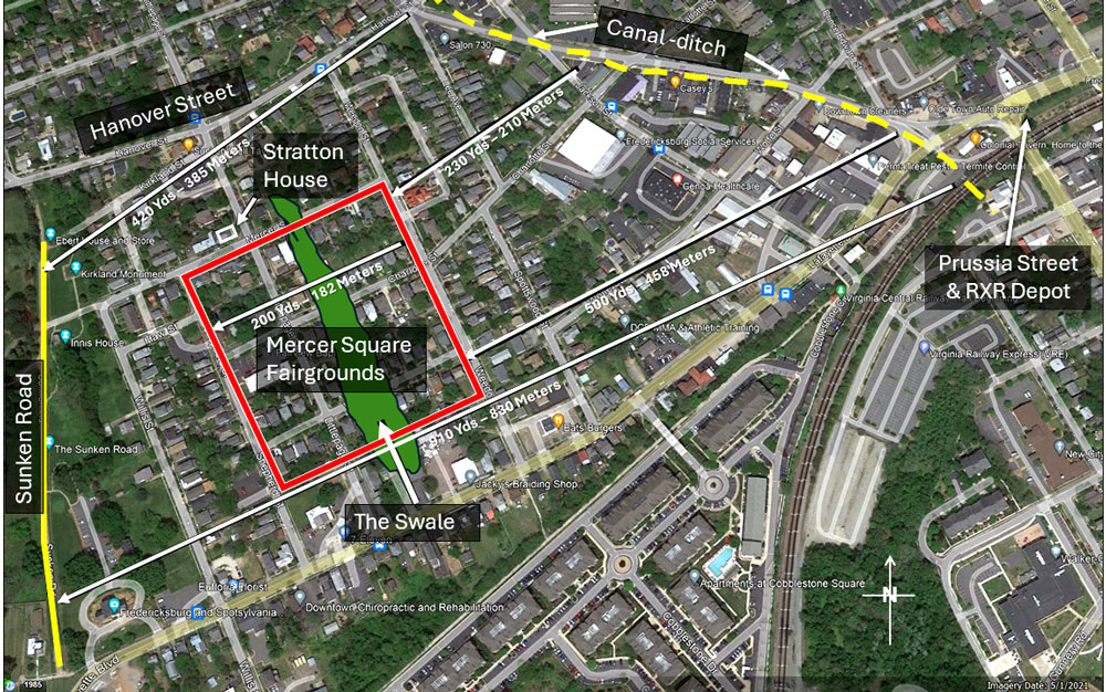
There were several obstacles which impeded movement of Union troops as they exited the environs of Fredericksburg. At the northern exit, these began with the Hanover Street bridge over the canal-ditch (click here). At the southern end exit at Prussia Street, there was the Richmond, Fredericksburg, and Potomac (RF&P) railroad and depot. Most assaults formed up along the low land just west of the canal-ditch, no matter which exit of the city was used, Hanover or Prussia Streets. From there, an open agricultural plain gradually rose to the stone wall and the Sunken Road at the base of Marye’s Heights. Now the assaulting troops faced more problems – fences.
Union Brigadier General (BG) Winfield S. Hancock devoted most of an entire paragraph in his official report to the impact of fences. While he focused on his division, virtually all Union formations faced the same problem. “One serious difficulty in the advance was in the nature of the obstacles … and the fact that a number of substantial fences intervened, which were required to be pulled down before the troops could continue their advance. Each of these fences destroyed the unity of at least one brigade. These obstacles naturally caused brigades and regiments to lose somewhat their solidity of organization for an assault, for all these operations were conducted under a terrific fire.”
Agricultural Fences
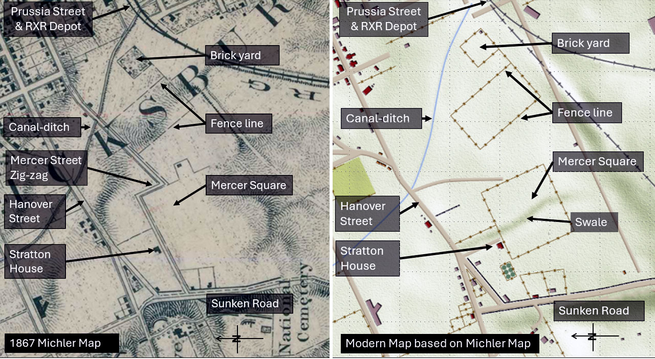
The open agricultural fields the troops traversed were sectioned off by fences. These were substantial in nature as, in many cases, they denoted property lines. The 1867 Michler map and a modern map of the same ground display some of the fence lines. There were others, but these are lost to time. Some authorities, such as Private John Keyser (see below), suggest that there were more fences extending as far as Hanover Street.
The first Union assault was conducted by BG William H. French’s Third Division. The lead element was BG Nathan Kimball’s 1st Brigade. This print of his assault shows the basic elements that confronted his infantry. The artist, John G. Keyser was a private with the 24th New Jersey Infantry Regiment. Drawn sometime after the battle, Keyser depicts the portion of the field he encountered as he remembered it. His depiction is of the typical agricultural fence he experienced.
BG Kimball was wounded and taken from the field. His courier reported to him later that “.. as they [Union infantry] crossed plowed fields on the double quick, they tore down fences…”
In the same attack, Private John B Landis of the 130th Pennsylvania regiment recalled, “On we went into a corn stubble field, and near a brick and a frame house [Stratton], over and through a board fence [Mercer Square fairgrounds fence]. We were now certainly now not more than 200 yards from the fatal stone fence at the foot of Marye’s Heights. The two houses mentioned stand on what is now the N.W. and N.E. corners of Fair and Mercer Street…”
Mercer Square Fairground Fence
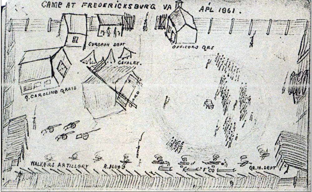
The most impactful fence system surrounded the agricultural fairgrounds known as Mercer Square. The fairgrounds were ten acres (four hectares) in size. It measured 600 by 726 feet (182 by 221 meters), with a long axis in a north-south orientation (read here). Between 1856 and 1861, the Fairgrounds was surrounded by a substantial fence and other improvements. After Virginia seceded from the Union, the fairgrounds became a training and assembly point for various Confederate units. In April 1861, a sketch of ‘Camp at Fredericksburg’ by one visitor captured the layout.
In the spring of 1862, Confederates retreated from Northern Virginia. They regrouped on the York peninsula to oppose the Union army under Major General (MG) George B. McClellan. When they withdrew from Fredericksburg, they burned the bridges across the Rappahannock River and all the improvements in Mercer Square except its fence.
In December, on the eve of battle, Confederate troops pulled down the fence wall boards closest to the stone wall and the Sunken Road. They piled these boards in random order to act as another impediment to the attacking Union infantry.
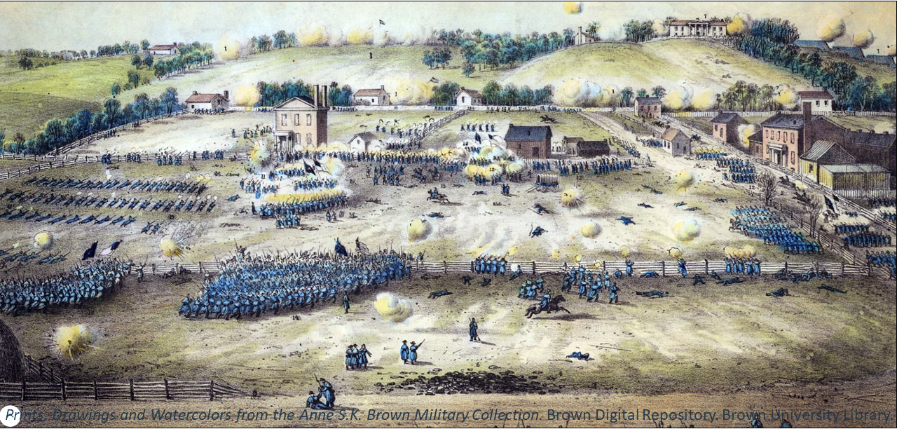
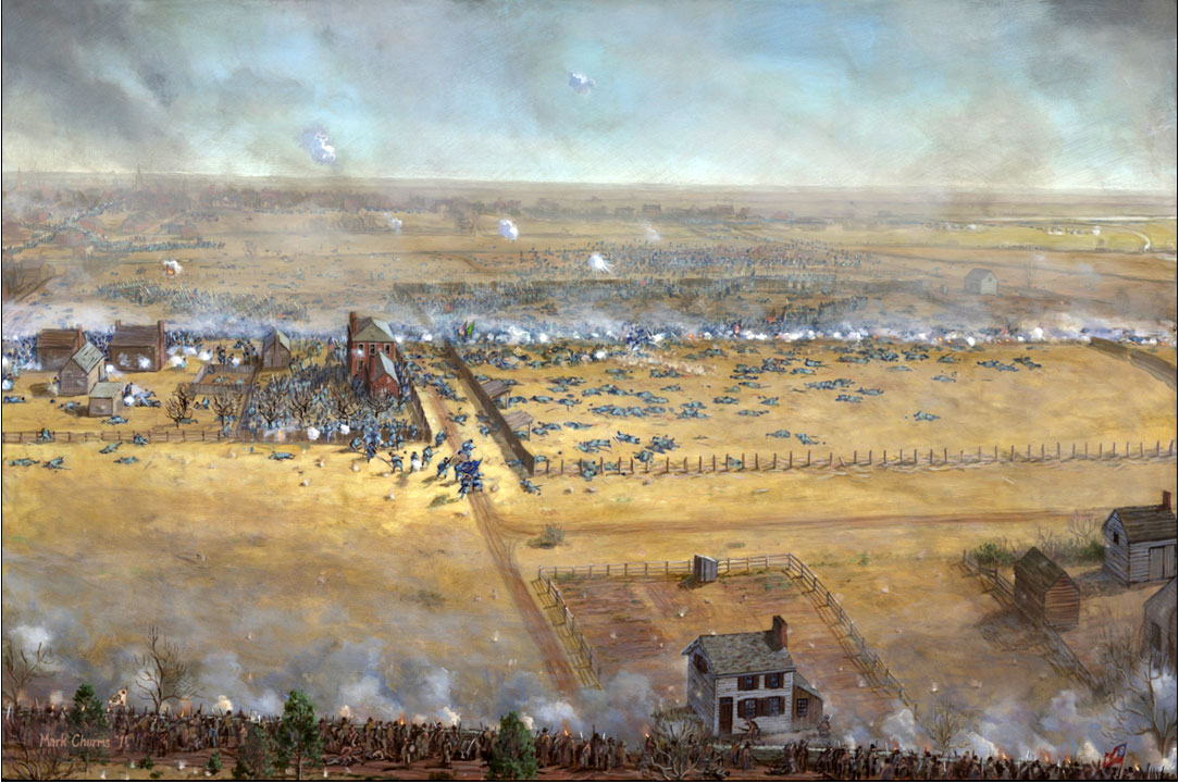
Working with the National Park Service, artist Mark Churms depicted the Union assaults against Marye’s Heights. The swale runs through the center of Mercer Square and behind the Stratton house. The Confederate defenders are along the bottom, standing behind the stone wall in the Sunken Road. One of the soldiers described it this way, “…The ground, over which we advances [sic] in that furious storm of iron hail and leaden rain, was a gentle slope from the city to the rebel works. Many of the solders are of the idea that the ground was a level field, but it was not so. In the days before the war this field was occupied a fair ground. The entire field had the appearance of a theatre; the enemy held the tier of seats, and the Union army occupied the stage. …The distance we had to advance under this terrible fire was from forty to sixty rods, and it was the longest fifty rods (275 yards or 250 meters) I ever saw.”
Here in Union soldiers’ own words are descriptions of the intensity of the slaughter in Mercer Square and the impact of its fence on movement.
Early in the battle, the 132nd Pennsylvania regiment’s adjutant, Lieutenant (Lt) Frederick L. Hitchcock was wounded in the middle of Mercer Square during the advance. He was initially knocked out by an artillery burst, but recovered and retreated, zigzagging under fire. “About fifty yards back was an old slab fence to my right, and I plunged headlong behind that, hoping to find shelter from those bullets. I fell directly behind several wounded men, two of whom rolled over dead from bullets that came through the slabs and which were probably aimed at me…”
Leander Cogswell of the 11th New Hampshire of BG Edward Ferrero’s 2nd Brigade described “…[W]e were ordered to make the final advance. In doing so, we had to climb over two high fences. …Now the Minies whistled, and the shells screamed over heads and through the ranks. Now the case-shot hummed, and the splinters from the fences flew in our faces…”
‘Cicero’ of the 13th New York described his entry into Mercer Square to a home-town newspaper. “…across the field, over, under and through two board fences, which rather disturbed the steadiness of our advance….”
Robert Goldwaite Carter of the 22nd Massachusetts described his entry, “We reached the next slight rise, the line half crouching as it ran, and moving sideways, as though breasting a ‘blizzard’….” After expanding all their ammunition, “We fell back through the lines a few yards. The Twentieth Maine swept forward…Our position was now along a board fence, skirting a sunken road.” There they discovered that they were in placed in a putrid corner of the fairgrounds: “now spread out in a vile spot, which had been used frequently by distressed men attending calls of nature” which fairgoers and others had used as a latrine.
An hour later survivors of the 118th Pennsylvania Infantry found “A board fence, with some of the boards displaced, others torn from the top, stood between the abrupt rise and the stone fence, nearer to the latter. The fence was about five feet high, or three boards, with intervals between them. Opposite the centre and right, the boards had been torn off down to the one nearest the ground…To the left, the boards still remained; the men heroically seized and tore them all away, some climbing over…The fatality that had followed the delay in their removal was marked by the bodies of the dead lying there, one upon another…”
Erastus Everson of the 18th Massachusetts found, “…the right company came squarely up on a huge board fence” then “Clubbed muskets soon made breaches in the obstacle, through which we went pell-mell over the killed and wounded, and reformed on the run….”
Jacob Cole wrote, “…Fifteen hundred yards of open plain had to be crossed with intervening ditches, broken bridges and rail fences. At one of these fences the Fifty-seventh [New York] halted for a moment and hesitated, as though asking whether it were possible to go further. It was a momentarily hesitation only, and when someone cried “Forward!” the boys climbed over the fence and advanced to the knoll within thirty yards of the stone wall. It was the furthest point reached that day.”
Wilford Wilson of the 145th Pennsylvania wrote, “The regiment advanced on the heights. It came to a board fence, splintered by bullets, which they pried open with bayonets. Once past this fence they came under a hail of gunfire…”
A soldier of the 69th New York noted, “…The now ragged Irish Brigade line swarmed forward towards the Rebel ranks, until the brigade encountered a 100 yard long “fence of upright plank, spaced along timber bars and supported by equidistant posts, fifty yards from the stone wall. As the Irish scrambled over the fence, “sheets of flame from thousands of muskets, withheld until this moment” erupted in their faces and stopped all but a few…”
Stratton House Fences
The Stratton House, immediately north of Mercer Square, was surrounded by fences with a small orchard and fence in the rear. Lt. Winthrop D. Sheldon of Company H, 27th Connecticut wrote, “The line now begins to waver…and presses forward to a brick house [Stratton]… the twenty-seventh…separated into several fragments, advancing to the right and left of the house. The time for a sudden dash had passed, and unable longer to stem the avalanche of fire, which seemed to gather intensity as we proceeded, the charge was continued only as far as a board fence, all full of bullet holes and torn by shot, less than a hundred yards [60 meters] from the famous stone wall…” This fence formed the back property line of wheelwright Allan Stratton’s property. This fence was aligned with the west fence line of Mercer Square fairgrounds. The area between the house and the fence became a deadly killing zone. By the end of the battle so many Union casualties accumulated here that the area behind Stratton’s house was the site of one of the two burial pits used to bury Union dead after the battle.
One of the last assaults was by BG Andrew Humphrey’s Division. Survivors of the 126th Pennsylvania wrote: “… On the side of this meadow, next to the enemy, is a slight bluff [at the canal ditch], under the shelter of which the assaulting columns formed for attack on the Rebel lines. From the apex of this bluff to the stone wall is probably a distance of a little over 300 [450] yards. This portion of the field is a slightly ascending plain. The only obstructions were a brick [Stratton] house and two board fences. The first of these fences was constructed of narrow boards, fastened horizontally to the posts on the side of approach, making it rather difficult to remove them. The second fence was made of broad boards, which were fastened vertically, like palings, on the opposite side of approach. Consequently, [these] were easily knocked off. The fences, when reached by our charging columns, were found to be in a fairly good state of repair, but both of them were completely razed to the ground by Humphreys’ charging column of Pennsylvania troops.” Despite whatever success the 126th may have had with the fences, they were also held up by the number of Union casualties which covered the ground. Their assault never made it to the Confederate line.
Other Fences
South of Mercer Square, BG Samuel Sturgis’ Ninth Corps troops discovered other fences. Private William P. Hopkins of the 7th Rhode Island wrote, “The regiment climbed a fence, crossed an old road and a slight swell of ground made a brief halt to reform the line. A position was then momentarily taken behind a second fence to wait the general order to charge across the plain.”
Fences were just another nail in the coffin (no pun intended) of the flawed Union assault against Marye’s Heights. When added to the punishing artillery fire, the progressively muddier agricultural field, which slowed the pace of the advance, and the power of the rifled musket used by Confederate defenders behind the stone wall, it is little wonder that Union troops failed to even come close to the stone wall. The conviction that they could prevail, and the supreme effort of the Union soldiers was not enough to overcome the odds stacked against them.
In front of Marye’s Heights, the Army of the Potomac lost 7,723 while the Confederates under Lieutenant General (LG) James Longstreet, lost 1,010 -lopsided numbers to be sure. Collectively, we remember the Battle of Fredericksburg for what occurred in front of Marye’s Heights amongst the fences of Mercer Square and the Stratton House.
Sources:
Books & Manuscripts.
A committee of the regimental association, History of the Thirty-Fifth Regiment Massachusetts Volunteers, 1862-65, Boston, Mills, Knight& Co., Printers, 1884, Pp 85-6.
Alexander, Ted, Editor, The 126th Pennsylvania, Shippensburg, PA: Beidel Publishing House, 1984, Reprint of A Sketch of the 126th Regiment Pennsylvania Volunteers, Chambersburg, PA: Cook & Hayes, 1869. p 44 &132.
Authorized by the Regimental Association and Prepared by its Committee, History of the 127th Regiment Pennsylvania Volunteers, Lebanon, Press of Report Publishing Company, nd, P 127. History of the 127th regiment, Pennsylvania volunteers, familiarly known as the “Dauphin County regiment.” Authorized by the regimental association and prepared by its committee : United States. Army. Pennsylvania Infantry Regiment, 127th (1862-1863) : Free Download, Borrow, and Streaming : Internet Archive
Bilby, Joseph G. Remember Fontenoy! The 69th New York and the Irish Brigade in the Civil War, Hightown, NJ, Longstreet House, 1995. P67.
Carter, Robert Goldthwaite, Four Brothers in Blue, Washington, Press of Gibson Bros, 1913, Pp 196-7. Four brothers in blue; or, Sunshine and shadows of the War of the Rebellion; a story of the great civil war from Bull Run to Appomattox : Carter, Robert Goldthwaite, 1845-1936 : Free Download, Borrow, and Streaming : Internet Archive
Cogswell, Leander W., A History of the Eleventh New Hampshire Regiment Volunteer Infantry in the Rebellion War 1861-1865, Concord, Republican Press Association, 1891, P 55, 59. A history of the Eleventh New Hampshire Regiment, Volunteer Infantry in the rebellion war, 1861-1865 … : Cogswell, Leander W. (Leander Winslow), b. 1825 : Free Download, Borrow, and Streaming : Internet Archive
Cole, Jacob H., Under Five Commanders; or, A Boy’s Experience with the Army of the Potomac, Paterson, N.J., News printing company, P 108, 111. Under five commanders; or, A boy’s experience with the Army of the Potomac : Cole, Jacob Henry, 1847- : Free Download, Borrow, and Streaming : Internet Archive
Gould, Joseph, The Story of the Forty-Eighth, Mt. Carmel, PA, Published by authority of the Regimental Association, 1908. P 99. The story of the Forty-eighth : a record of the campaigns of the Forty-eighth Regiment Pennsylvania Veteran Volunteer Infantry during the four eventful years of its service in the war for the preservation of the Union : Gould, Joseph, 1840- : Free Download, Borrow, and Streaming : Internet Archive
Harrison, Noel G., Fredericksburg Civil War Sites, Volume Two, Lynchburg, H. E. Howard Inc, 1995, Pp 160-164.
Hitchcock, Col. Frederick L., War From the Inside; The Personal Experiences, Impressions, and Reminiscences of One of the ‘Boys’ in the War of the Rebellion, J.B. Lippincott Company, Philadelphia, 1904, P 123. War from the inside; or, Personal experiences, impressions, and reminiscences of one of the “boys” in the war of the rebellion : Hitchcock, Frederick L. (Frederick Lyman) : Free Download, Borrow, and Streaming : Internet Archive
Hopkins, William P., The Seventh Regiment Rhode Island Volunteers in the Civil War 1862-1865, Providence, RI, Snow and Farnham Printers, 1903, P 45 The Seventh Regiment Rhode Island Volunteers in the Civil War, 1862-1865 : Hopkins, William Palmer, 1845- : Free Download, Borrow, and Streaming : Internet Archive
Orwig, Joseph R., History of the 131st Penna. Volunteers, war of 1861-5, Williamsport, Pa., Sun book and job printing house, 1902, P xx. Orwig, Joseph R. (Joseph Ray), History of the 131st Penna. Volunteers, war of 1861-5 : Orwig, Joseph R. (Joseph Ray), b. 1838 : Free Download, Borrow, and Streaming : Internet Archive
Parker, John L., History of the Twenty-Second Massachusetts Infantry, Boston: Rand Avery Company, 1887, P 228. Henry Wilson’s regiment. History of the Twenty-second Massachusetts infantry, the Second company sharpshooters, and the Third light battery, in the war of the rebellion : Parker, John Lord : Free Download, Borrow, and Streaming : Internet Archive
Sauers, Dr. Richard, ed, The Civil War Journal of Colonel William J. Bolton, 51st Pennsylvania, Combined Publishing Pennsylvania, 2000, P 100.
Sheldon, Winthrop, D., The Twenty-Seventh; A regimental History, New Haven, CT, Morris and Benham, 1866, P 28. The “Twenty-seventh, a regimental history : Sheldon, Winthrop Dudley, 1839-1931 : Free Download, Borrow, and Streaming : Internet Archive
Survivors’ Association, History of the 118th Pennsylvania Volunteers (Corn Exchange Regiment), Philadelphia: J.L. Smith, Map Publisher, 1905, Pp 128-9. History of the 118th Pennsylvania Volunteers Corn exchange regiment, from their first engagement at Antietam to Appomattox. To which is added a record of its organization and a complete roster. Fully illustrated with maps, portraits, and over one hundred illustrations, with addenda : United States. Army. Pennsylvania Infantry Regiment, 118th (1862-1865) : Free Download, Borrow, and Streaming : Internet Archive
The War of the Rebellion: A Compilation of Official Records of the Union and Confederate Armies, 128 vols. (Washington D.C., 1890-1901. Series 1. http://ehistory.osu.edu/books/official-records
No. 4. Return of casualties in the Union forces commanded by Major General Ambrose E. Burnside, U.S. Army, at the battle of Fredericksburg, Va., December 11-15, 1862, OR 21, Pp 129-145.
No. 55. Report of Brigadier General Winfield S. Hancock, U. S. Army, commanding First Division. OR 21, P 228.
No. 265. Reports of Surg. Lafayette Guild, C.S. Army, Medical Director, with lists of killed and wounded. OR 21, Pp 558-562, plus, 572-3, 577, 583-4, 591, 610, 623-4, 629, 635, 640, 662, 665, & 680.
Worsham, John H., One of Jackson’s Foot Cavalry: His Experience and What He Saw During the War 1861-1865, Including a History of “F Company,” Richmond, Va., 21st Regiment Virginia Infantry, Second Brigade, Jackson’s Division, Second Corps, A. N. Va., Pp 18, 21. One of Jackson’s foot cavalry : his experience and what he saw during the war 1861-1865, including a history of “F company,” Richmond, Va., 21st regiment Virginia infantry, Second brigade, Jackson’s division, Second corps, A. N. Va. : Worsham, John H : Free Download, Borrow, and Streaming : Internet Archive
Newspapers, Periodicals and Manuscripts.
Erastus W. Everson, Philadelphia (PA) Weekly Times, 3/4/1882, Forward Against Marye’s, 18 Massachusetts.
———————-, “Forward Against Marye’s,” Annals of the War, USAMHI.
Landis, John B. Personal Experiences in the War of the Rebellion, Betty Carson, Norristown, Pennsylvania, P 22.
Unknown author, Report of Kimball Brigade attack against Marye’s Heights, Kimball Papers, Lilly Library, Indiana University, Bloomington.
Wilson, Wilford M, 145 PA, December 2011 newsletter of the Sons of Confederate Veterans, Joseph B. Kershaw Camp #82, Camden, South Carolina
Internet.
Deed Book/Page R/349/351 14 March 1855, Caldwell et. al sells 10 acres to Mayor of Community of the Town of Fredericksburg.
Internet.
April 1861 sketch of Mercer Square. Library of Virginia, Robert Alonzo Brock Collection, 2010-Fall.pdf (virginia.gov). The original is at the Huntington Library.
Reuben Lindsay Walker and Purcell Artillery. History of the Purcell (Virginia) Artillery in the Civil War (civilwarintheeast.com)
History of the Richmond Purcell Artillery History of the Purcell (Virginia) Artillery in the Civil War (civilwarintheeast.com)
Mysteries & Conundrum, Jan 26, 2011 by John Hennessey. Visual evidence of learning–the Fairgrounds by O’Reilly | Mysteries & Conundrums (wordpress.com)
April 1861 sketch of Camp Mercer. Broadside, Library of Virginia, Robert Alonzo Brock Collection, 2010-Fall.pdf (virginia.gov)
Reuben Lindsay Walker and Purcell Artillery. History of the Purcell (Virginia) Artillery in the Civil War (civilwarintheeast.com)
History of the Richmond Purcell Artillery History of the Purcell (Virginia) Artillery in the Civil War (civilwarintheeast.com)
Original Sketch of Kimball’s Assault by John G. Keyser. Civil War Sketches Collection – The Warren and Reba Lummis Genealogical & Historical Research Library (warren-and-reba-lummis-research-library.org)
Images:
Keyser, John G., “Charge of Kimball’s Brigade: in the Battle of Fredericksburg Saturday Dec. 13th 1862 ” (1863). Prints, Drawings and Watercolors from the Anne S.K. Brown Military Collection. Brown Digital Repository. Brown University Library. https://repository.library.brown.edu/studio/item/bdr:234316/

Another fantastic chapter, Peter. Thorough analysis, as always.
LikeLike